GREENLAND
NEW Upload 26 January 2009 Greenland. All coastal and mountain areas of Greenland are covered; only the principal icefield is missing. For the principal icefield, DEM data has been reprojected (thanks to Trond Nesøen for the provision of projection data) and resampled from 1km NSIDC data and will be merged with coastal data contours for a complete Greenland DEM, expected around 31 January. The Greenland contours conform to WGS84 and do not need to be reprojected.
The contours were captured from local 100K (Gunnbjørn area), 250K and 500K topographic maps. The contour interval is 100 metres, so the true resolution in low relief areas is low. Accuracy is much better than anything else currently available from internet sources. But the heights of the many ice domes around the coastline may not be accurate; these have never been measured other than by low resolution radar satellites, and measurements from radar sources differ significantly. There are also some slight positional inaccuracies, especially on the west side; north and east areas are generally, but not without exception, better. These inaccuracies may be addressed in future editions.
SIBERIA
Upload 24 October 2008; revisions and extensions 22 November 2008, 28 November 2008
T44-T49 N 76°00' E 82°00' to N 82°00' E 114°00'
S44-S50 N 72°00' E 82°00' to N 76°00' E 116°00'
R44-R50 N 68°00' E 82°00' to N 72°00' E 116°00'
Q44-Q50 N 64°00' E 82°00' to N 68°00' E 116°00' (NEW Q49 is now complete)
P44-P50 N 60°20' E 82°00' to N 64°00' E 116°00'
NEW
Upload 5 November 2008, revised 13 November and 22 November 2008
R58-01 N 68°00' E 166°00' to N 72°00' W 174°00'
Q58-02 N 64°00' E 166°00' to N 68°00' W 168°00'
P59-60 N 62°40' E 168°00' to N 64°00' E 180°00'
NEW
Upload 31 January 2009
P50-S51 N 60°20' E 114°00' to N 74°00' E 122°00' and N 60°20' E 122°00' to N 64°40' E 128°00'
E160°-166° is expected soon and the rest of North Siberia by June 30.
In accordance with the source maps, the data projection is Pulkovo 1942. A table of Pulkovo 1942 coordinates for each WGS84 degree intersection can be downloaded here. The accuracy of this table is well within the horizontal accuracy of the source maps. My thanks to Trond Nesøen for the provision of this table, and to Aleksander Yashin for identifying various errors and areas for improvement.
SCANDINAVIA and NORTH WEST RUSSIA
E 0°-6° E 6°-12° E 12°-18° E 18°-24° E 24°-30° E 30°-72°
N 68°-72°
R33
R34
R35
R
N 64°-68°
Q32
Q33
Q34
Q35
Q
N 60°-64°
P31
P32
P33
P34
P35
P
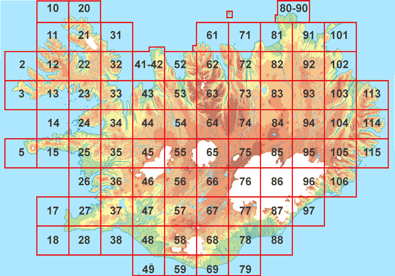
ICELAND
Download Iceland. The Iceland tile guide can be found here; to translate, subtract the last digit from 9, and replace the other digit(s), null-11, with A-L respectively. There are slight differences, in that each text tile covers exactly 44km x 40km. The projection is local Icelandic.
Edge Matching
Some users have reported problems because of the imperfect matching of some hydro vectors with those on neighbouring tiles, and the consequent "bleeding" of water bodies. Edge matching techniques have been applied to minimise this problem, but because of the integer values of the pixel locations, and the variable pixel scale according to latitude, exact matching of vectors between north and south boundaries, and where the source scale switches between 100K and 200K, is not possible.
Within each tile, all hydro vectors should interconnect, and type 19 vectors (lakes of unspecified elevation) do not cross tile boundaries. It should therefore be possible to generate "dry" DEM data, assuming that all type 18 vectors cross dry land, flattening only the type 19 enclosures. Then, for each tile, water body incidence maps can be generated, and flattened elevations calculated for water body areas. These elevations can then be translated to WGS84 and overlaid onto the dry elevation data.