Paths and Names
C:\G The drive and folder path. These can be amended.
Projection
The Russian maps are based on the Pulkovo 1942 coordinate system, which is slightly offset from WGS84.
The geographic names files were created from USGS data, and the files are based on the same 6°x4° blocks as the DRG folders, see above.
Each record uses the following fields:
Records on US territory come from a different dataset and are named differently, more information about these will be posted soon.
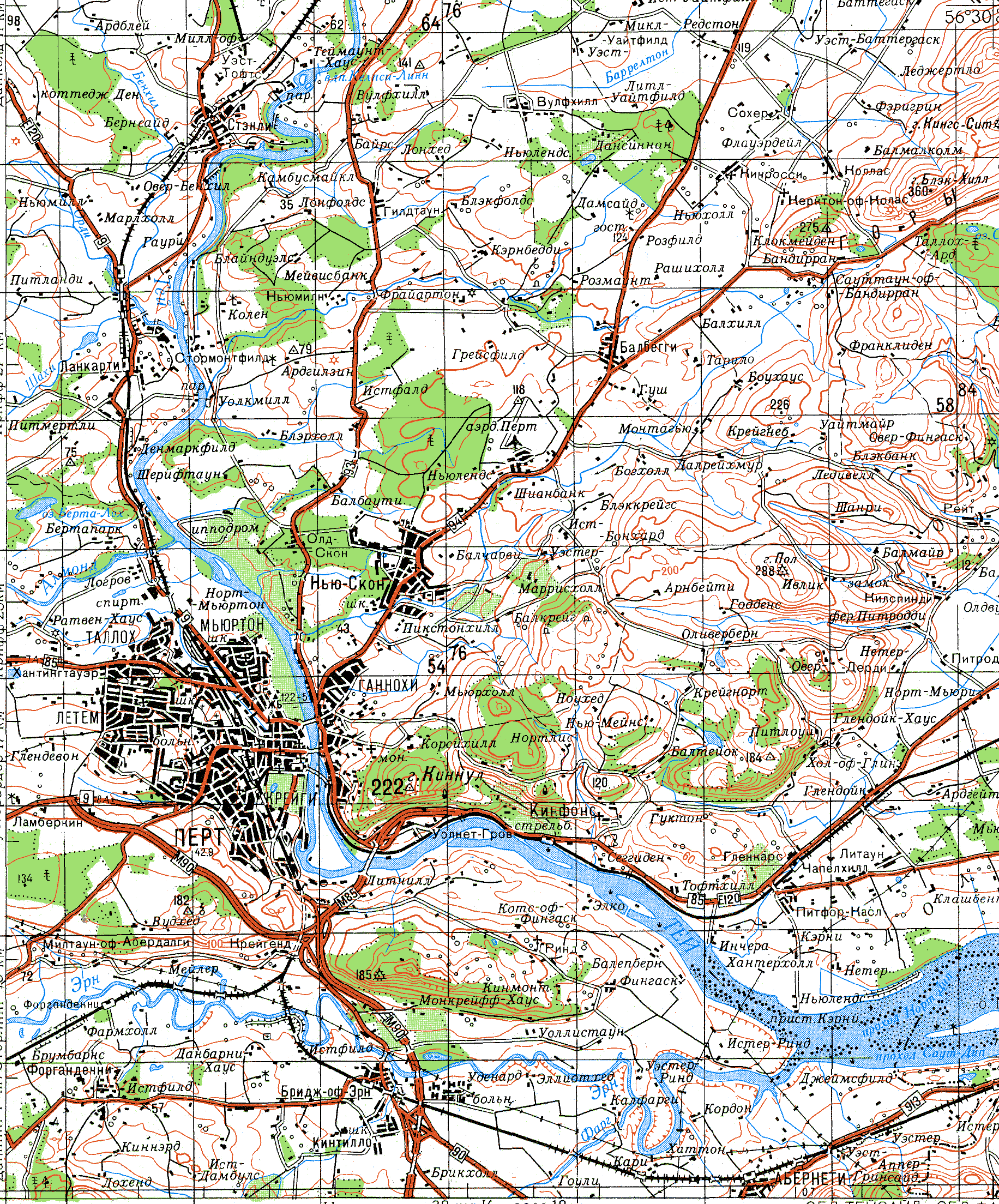
RASTER MAPS AND FOLDERS
Most of maps that I can supply are arranged into block folders. A typical map path may look like this: C:\G\100N\O30\KC.gif.
100N The map series. 100 is for 100k (scale 1:100,000); N is for northern hemisphere.
O30 The folders cover 6°x4° each, and are labelled A(0°-4°) to U(80°-84°), and 01(180°-174°W) to 60(174°-180°E). Example: K31 covers 40°-44°N, 0°-6°E.
KC The 100k maps, AA to XX, cover 15'x10' each; the 200k maps, AA to LL, cover 30'x20'; the 250k and 500k maps, AA to LH, cover 30'x30'. Maps 100k-AA,XA,AX,XX are in the south west, south east, north west and north east corners respectively.
Some map series have different parameters, but the principle remains the same.
My raster maps are, like most international digital elevation models, projected geographically. Each rectangular map image covers a rectangular area of latitude and longitude. This has considerable advantages for the programming of seamless viewing, particularly across UTM boundaries. There is slight distortion, but the error seldom exceeds 1%. For each map series, the Y dimension is constant, but the X dimension varies, in steps, with the cosine of latitude. There are 10 overlapping pixels between each map.
GEOGRAPHIC NAMES
0-1 The record length, in bytes.
2 Region code (RC), see USGS summary. Note that the other fields in this document have beem substantially altered.
3 Amemdment flag. I found most of the records from the USGS were found to be inaccurate, often by an arc minute (2km) or more. If b3=1, then coordinates of the record have been altered from their original USGS position. If b3=0, the coordinates are unaltered and may be inaccurate.
22: Denotes the significance of the record (1-5, 0=no data), and is also closely related to 3. If b3=1 and b22=0, the record has been altered but subsequently rejected, and should be ignored. If b3=0 and b22=0, the record coordinates are unaltered from the USGS data.
4-7, 8-11 Longitude and latitude, in arc seconds relative to 0°N, 0°E.
12-15 Elevation in metres. 0 if not available.
16 Feature classification (FC), see USGS summary.
17-21 Feature Designation Code
23 Name Type NT
24-25 Country Code, see and CC2.
26-31ADM1,ADM2,LC
32-37 Pointers to names of type 0-5, relative to start of record (0=not available).
1: short, 2: generic, 4: name with accents, see RC and accent codes, 5: name without accents. Each name starts with its name type (1-5) and is terminated by a byte of 5 or less.
Features named exclusively in capitals have been added, and do not appear in the raw USGS data.