This page lists summit elevations and other topographic claims, which, in my opinion, many authorities get wrong.
Update January 2025 I have not been editing this page for some time and a recent check revealed that many of the source links are dead or obsolete. It is in the process of being overhauled.
Glossary: SRTM; GPS; HP=High Point. Numbers in square brackets refer to acknowledgements. Readers with knowledge of anything that should be added to this page: you are welcome to contact me at jonathan--at--viewfinderpanoramaszorg. I hate spam so you will need to replace the --at-- with the symbol and the z with a dot.
Summit Elevations: Spot heights and Google Earth. It is occasionally asked why elevation maxima at mountain summits on Google Earth fall below published and GPS spot heights. The terrain data used by Google Earth to generate three dimensional images are, for most of the world, derived from digital elevation models, in turn derived primarily from SRTM data. These data typically have a three arc second resolution, i.e. they provide elevation values at three second (approximately 90 metres at the equator) intervals. Each given 3 second value is averaged over a 3 second x 3 second area. If a mountain summit falls within such an area, the given elevation for that area will necessarily be lower than the elevation at the summit. The difference depends on the local relief; the steeper the summit, the greater the difference. Differences in the order of 15 metres are fairly normal, and differences of more than 50 metres can, and do, occur. It is also worth mentioning that that GPS devices measure ellipsoid heights, which must be converted to the geoid using data stored within the GPS device itself. The quality of these data are, for some parts of the world, such that GPS readings of up to +/- 10 metres may occur along a sea shore, with corresponding errors at higher elevations. It is further worth noting that, in some places, especially in areas of high relief, SRTM data are incomplete, and in the absence of any other data, Google have filled the gaps using interpolation. Consequent differences between Google summit heights and actual summit heights can run into hundreds of metres, especially in some tropical areas where no alternative data sources are available.
Why these elevations should be corrected. The Internet has become an important medium for the free flow of knowledge, to the general benefit. But where that information is wrong or inaccurate, that benefit is compromised. And there are practical reasons why high point inaccuracies compromise that benefit.
Many climbers today carry GPS devices. If I were climbing in the High Andes and my GPS showed 6500 metres, but I were starting to work harder to breathe in the rarified atmosphere, I would surely want to know if I were 300m or 400m below the summit. And if the mist were down, I may then need my GPS device to be sure that I had reached the summit. For that I would need an accurate mountain elevation to compare with my GPS reading.
The day is surely approaching when all aircraft, including light aircraft, will be equipped with computers carrying digital elevation/obstacle data and GPS receivers connected to a siren. These will provide cheap and reliable safety technology in mountain mist. But if the elevation data is not accurate then the value of this technology will be reduced.
More generally, I cannot resist my urge to express my contempt for politically and commercially motivated elevation inflation. Where elevations are outside the error margin of the most accurate available elevations, official and august authorities should correct them in the manner that has been done by those of Brazil and Venezuela, and commercial organisations should not continue to dishonestly bill the inflated elevations.
I have a further argument. Recently products like Google Earth and NASA World Wind have been made freely available. The fly-by effects are amazing, but for mountainous areas their quality is compromised by poor quality digital elevation data. It is time to sweep away the fiction and put together a complete and accurate worldwide digital elevation model. I am working on this, see here.
It could be argued that inflated elevations contribute positively to safety. I strongly disagree. To give an analogy: I once set my watch ten minutes fast in the hope that it would make me more punctual. But soon I got used to this deliberate error margin and the ultimate effect on my timekeeping was negative.
So to all webmasters of sites that include high point data I say, please check the summits that follow, and if you find my evidence convincing, please update your information!
I do not know whether or not the elevations that imply that Monte Pissis is higher are still officially believed, but they were for some time and still appear on some maps. For more details see the mountain's references section on Wikipedia. An often quoted elevation of 6872m for nearby Bonete Chico is also inflated; its true elevation is in the mid 6700s. Cerro Mercedario is officially quoted at 6770m but SRTM data suggests it is about 6720m and an (albeit vague) GPS report is consistent with this.
As far as I am aware the elevations on John Biggar's list of 6000m Andes summits here are accurate, and the elevations given in the 2005 edition of his book "The Andes: A Guide for Climbers" are as accurate as the current state of knowledge (2005) permits.
Despite being relatively accessible, widely photographed, and increasingly popular, this group remains one of the world's worst surveyed. Inconsistencies abound. Cerro Paine Grande's Cumbre Principal is universally quoted at 3050m but it is interesting that when converted to feet this elevation tops 10,000. It seems that, once upon a time, it was in someone's interest to bill this as a 3000m/10000ft summit, and this elevation has not up to now been challenged or investigated. Calculations from geometric analysis of some photographs suggest that its true elevation is about 2600m, although more recent analysis of narrower angle and higher resolution/quality photography (see 1) suggested that it is nearer to 2800m. This was confirmed in August 2011 when an expedition reported it to be 2884m (see 2). There are definitely major errors in several of the elevations of other summits that appear on most maps. Please, please could someone go and survey this range properly!
Other Patagonian summits. The HP of Chilean Patagonia, San Valentin, is officially deflated to 3911m on the Chilean map but SRTM shows that its true height exceeds 4000m, and this is supported by a GPS survey by a Chilean expedition. Another highly prominent summit, belonging to Volcan Lautaro, is officially under 3400m but the SRTM cells rise to a maximum of 3560m. The lesser known but still prominent volcano Cerro Maca, at latitude 45S, has been quoted at over 3000m but SRTM suggests it is about 2300m.
The official elevation is 5611m but this is from an old survey, and elevations over 5700m are widely quoted. An elevation of 5636m was mesaured by 2003 expert GPS survey (see page 23) appears to have been generally accepted. It is supported by ALOS data.
Ixtaccihuatl and Popocatepetl. The most frequently quoted elevation for nearby Iztaccihuatl is 5286m but SRTM (top 3" cell 5216m) and the official Mexican survey INEGI (see below) agree that the actual elevation is about 5220-5230m. A frequently used elevation of 5452m for Popocatepetl is probably also too high; SRTM and INEGI suggest 5410m may be accurate, but this is less clear cut. See the following files:
For details of the 3098m measurement see the Caribbean Journal of Science. The reading is consistent with both SRTM data and a GPS measurement obtained in Jaunary 2005 by topographic research colleagues Adam Helman, Edward Earl and Bob Packard.
This is not a 3000m+ summit.
This is not a 5000m+ summit. [2]
The 6267m elevation was measured by a British soldier called Mike Jenkins by DGPS in 1993, and I do not think it is officially disputed by Ecuador, but an older elevation of 6310m is still often seen in print and on some websites.
They were measured in 2024 by DGPS survey by a maths professor and GPS expert. The two summits were both measured at 5775 metres by a 1939 expedition, with subsequent ice cap melting likely accounting for the difference. The 1939 figures are still sometimes quoted. Access since then has been obstructed by local resistance and conflict.
In general, elevation inflation does not occur in High Asia. In particular, the excellent Finnmaps of Nepal re-affirm the traditional elevations. Despite lack of local access, the Survey of India was able to measure the majority of Himalayan summits with remarkable precision as early as the mid-19th century. An unfortunate blip occurred about 20 years ago when someone suggested, on evidence that he conceded was weak, that K2 may be higher than Everest. Unfortunately sensation seeking journalists, no doubt with their minds tuned in to sales at the expense of fact, reported this as if it were proven. Infact, without exception, significant elevation errors for major summits in High Asia occur in areas outside the scope of the Survey of India. Some of China's most prominent mountains are covered by an excellent series of 14 "snow mountain" maps, but elsewhere, unfortunately, where inflated elevations have become established, some authorities seem to be unwilling to revise them.
For a long time, much of the Tibet plateau was thought to be about 700 metres higher than it is. Its general elevation has been fairly well known since the 1980's. but, twenty years later, many publications and websites are still quoting summit elevations based on older Tibet plateau elevation assumptions. Ulugh Muztagh is one of many examples of this.
As far as I checked it, the Highest Mountains list here looks to be the most complete and accurate that is currently available. Refinements to this list are ongoing.
Sources in agreement: SRTM, GPS and the Soviet 200k topo of the area. And contrary to the claim made by the Indian and many other authorities, there are higher motorable roads in Tibet. For more details, including a list of GPS observations, click here.[5]
At one time Guinness World Records were supporting a height of 5682 metres for this pass while simultaneously claiming that its records were "tested, verified and elevated above all suspicion". The highest motorable road pass rises to 5799 metres at Umling La. For more information about high passes, see my high passes page.
Also known as Muztag Feng. The true elevation was established by a Sino-American expedition in 1985 and confirmed by the official Guide to Mountaineering in China, detailed Chinese mapping, and by SRTM. The 2005 Penguin Book of Facts is among those that still give an elevation of more than 7700m. So do Encyclopedia Britannica and the Times Atlas of the World, which gives an equally crazy elevation for a similar mountain called Buka Daban about 250km further east. See above. For more information, see summitpost.
Sources in agreement about this: SRTM, GPS, the Soviet 200k topo of the area, the (official) Guide to Mountaineering in China, and summitpost. SRTM suggests the elevation is most likely to be about 6530m; the other sources are all within 100m of this.
Update 11.09.2011: contrary to the suggestion posted here earlier, I now believe the official elevation and that there has been no elevation inflation. The summit was measured in 1858 at 7298 metres and revised to 7326 metres on modern Chinese mapping.
The differences are small, but they raise interesting questions about which is higher and the HP of Bhutan. These are discussed here. This page and its associated color relief map, showing the topographical divide, support the new elevations and argue that, despite the view of most authorities, Kula Kangri is wholly in Tibet and therefore NOT the HP of Bhutan, whatever its height with respect to KP [1].
The Guide to Mountaineering in China gives 7649m. Confusingly, the authoritive Chinese Snow Map gives both 7719m and 7649m on different sections of the map. Both sources give the elevation of the northeast dome as 7625m. In "Kongur: China's elusive Summit" Chris Bonington writes that seen from the NE dome "(the main summit) is undoubtedly the highest point on Kongur, though probably by not more than thirty metres or so". Despite clear weather and lack of time, Bonington's party climbed both summits because, on reaching the main summit, they found that they could not be sure that the NE summit was lower. The two summits are ±700m apart; had there been a 94m height difference they would surely have seen clearly that the NE summit was lower. Therefore I concluded that the 7649m elevation is more accurate. I have subsequenly been informed of GPS readings of 7669m by Russian and Italian mountaineers, but reliable details of this are lacking. [1]
The Yazghil Domes are quoted in the 7300's by all maps that I have seen, but some authorities go up to 7559m. Higher quotes are usually attributed to the main dome but not the north dome. A high level photograph in the Japanese Karakoram study shows such an implicit difference in height between the two domes to be just so much hogwash. There is also enough local SRTM data on around these summits to trash any summit claim over 7400m. 7559m is 24800 feet and could be the creature of the accidental or convenient juggling of 8's and 0's [10].
This is the mountain that is well known to pilgrims of many faiths as "Holy Mount Kailash". Internet sites and a well known august authority give it more than 6700m but I prefer not to be in awe of these and to go with the Guide to Mountaineering in China and its Chinese Snow Mountain map, which agree on 6638m. Similarly, internet sites give relatively nearby Naimonanyi (aka Gurla Mandhata) 7728m but the above Chinese authorities agree on 7694m.
The relevant sentences from the above link translate into English as follows: It only just scrapes the magic 7000 metre limit because of its white ice and snowcap. But that does not count. The rock peak is just 5 metres short of this, otherwise it would be the most northerly seven thousander (peak) in the world.
Readers can decide for themselves whether the ice and snow cap should count towards the 7000m mark, or whether authorities should demote Mont Blanc to under 4800m and the South Pole to somewhere around sea level. The existence of a 7000m+ ice and snow cap is substantiated by a trip report by Peter Csizmadia here (in Hungarian). The exact height of this probably varies with snow conditions. The higher elevation means that this summit qualifies for the 7000m "snow leopard" list.
Compatible sources: Russian 200K map and SRTM. The highest 3" SRTM cell in Bangladesh is 1049m at N 21°47'12" E 92°36'36", where the Russian 200K map gives a spot height of 1052m in the Mowdok range, on or close to the borders with Myanmar and India. More recent claims by the Bangladeshi authorities that nearby Tazing Dong is their national high point are equally incompatible with reliable GPS(supplied by Ginge Fullen)/SRTM/Russian sources.[8]
4620m, which is based on an Italian military survey dating back to the 1930's, is way above anything compatible with SRTM. Over to Prof. Hans Hurni of the University of Bern institute of Geography: "This project did a full cover survey with air photography (about 1:40,000), triangulation and stereoscopic mapping of the whole country in the late 1960s early 1970s. To my knowledge, the elevation names are rather accurate (to the meter), and Ras Dejen (not to be spelt Ras Dashan), the highest peak of Ethiopia, is given the altitude of 4533 m asl, based on a polygon they started from the Red Sea"[6]. 4533m is consistent with SRTM data, but in 2007 a DGPS survey by a French-Italian team found the slightly higher elevation of 4550 metres, which is within the likely SRTM error margin.
The highest 3" SRTM cell in Gabon appears to be on Mont Bengoué, 1070m at 00°57'21"N, 13°41'09"E. The CIA also give a wrong 903m high point for neighbouring Congo, whose true HP is Mont Nabeba, 1020m at 1°50'39" N 13°59'27" E [8] [11].
The highest 3" SRTM cell in Botswana appears to be on Monalanong Hill, in the SE of the country, 1494m at 24°50'27"N, 25°39'54"E, but there are other nearby competing high points, Otse and Kanye, that are within the SRTM error margin. Analysis of local SRTM cells suggests that a GPS reading of 1496m obtained by Ginge Fullen on Otse is accurate. [8][11]
The lower height, which, unlike the higher and more commonly quoted height, is consistent with SRTM data, was official at the Statistical Centre of Iran. Unfortunately this link is now dead. Damavand was measured in 2007 by Norwegian climber Petter Bjørstad using hand held GPS. His results can be found here (see "Day 2, August 14, summit day"). He writes:
The highest local 3" SRTM cell is 3653m and the cells would seem to be incompatible with a high point exceeding 3700m. The elevation given here and here looks good to me.
The highest local 3" SRTM cell is 4024m which suggests that the true elevation is probably not higher than 4070m, and may be no higher than 4040m. Update: in March 2015 a hand held GPS reading of 4045m was reported by English climbers Rob Woodall and Adrian Rayner.
SRTM data, whose highest 3" cell in the area is 1424m, firmly upholds and is consistent with the higher elevation.
The elevation of 4884m, which is consistent with IFSAR data, is provided by the "Seven Summits" pages, but elevations of more than 5000m are still given by several august authorities. Some of these may be based on information dating back to when there was a large and higher icefield nearby. This icefield has long since melted away.
Sources: GPS, SRTM, higher resolution IFSAR data, and official 50k mapping.
The summit was reached by Petter Bjørstad and others in June 2014 and measured by GPS. Trip Report
Sources: IFSAR data, and the relevant peakbagger page which supplies altimeter evidence. The higher elevation may be from a survey pre-dating an eruption.
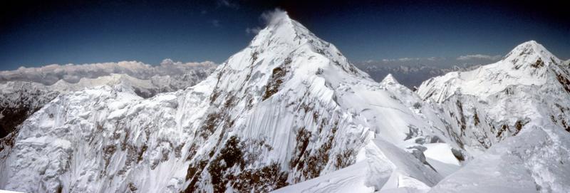
Shkhara, HP Georgia, Caucasus mountains.
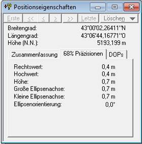
The 5193m elevation was obtained by Austrian geographer Peter Schoen, and Boris Avdeev from the University of Michigan, with the support of GeoAT, in July 2010 and published in November 2010. The lower alternatives are those of spot heights that appear on Soviet era mapping. The highest point, which does not appear to have ever been accurately measured before, lies slightly further east along the main ridge. The 5201m elevation was a reasonable estimate of the true height based on previously available information. The 5193m elevation may be subject to seasonal variations in snow and ice cover; the rock head elevation is lower.
Etna, Sicily.
I think the official elevation is 3323m, but most authorities give 3340m+. The elevation may vary due to volcanic activity, but the most up to date GPS reading is compatible with the lower figure. The error is fairly small, but commercially motivated inflation seems likely. Update 2025: the summit was reported to have been raised to over 3400 metres by recent volcanic activity.
Cima di e Follicie, North Corsica
Despite what is stated by some older authorities, this summit is 1324m high, and this summit, not nearby Monte Stello (1307m), is the high point of Corsica's northern peninsula. Source: official French 100k and 25k mapping, and SRTM. [3][4]
In 2015 a temporary case of elevation deflation of US national high point Denali came to my attention. The USGS should not have accepted the height of 6168 metres on the basis of 5m Intermap IFSAR data. I have seen these data for other parts of the world and despite their nominal 5m resolution, errors of more than 20 metres in areas of very high relief terrain are very common. I am also aware of a hand held GPS measurement that upholds the older 6194 metres. An error of more than 20 metres in this measurement is unlikely. In the summer of 2015 a new GPS survey was completed and on 2 September a height of 20310 feet (6190 metres) was officially announced. The change from 6194 is within the error margin of hand held GPS and the likely error margin of the older survey.
I am not aware of any significant elevation inflation in the US, but two commercially motivated falsehoods about visible area have come to my attention.
Mount Diablo, near San Francisco, California more information
Rock City, Lookout Mountain, Georgia more information
I am no more aware of significant elevation inflation in the UK than in the US, but an old claim that Snowdon, the highest mountain in Wales, is visible from The Wrekin, is supported by a Wrekin summit indicator. There is no line of sight between the Wrekin and Snowdon. A detailed analysis of the claim's long history, written and supplied by David Squires, makes interesting reading. It shows how easily myths can be reproduced and become accepted fact.
Elevation Precision. Some authorities quote an elevation for Everest of 8850m, as against the older 8848m, and elevations for Mont Blanc vary from 4807m to 4810m. Similar examples can be easily found.
In spite of my comments about accuracy at the top of this page, my personal view on the above and similar examples is that, while errors in excess of 20m should definitely be exposed, and smaller errors should be exposed if they create incorrect highpoints, it is neither necessary nor always possible to determine elevations to the nearest metre. I can think of several reasons for this.
GPS. The US military Global Positioning System consists of a fleet of satellites. Hand held devices which can communicate with these satellites to determine position and elevation to an accuracy of about 10 metres can be obtained from most outdoor shops. When using a GPS device to determine elevation, it is important to ensure that:
SRTM. The Shuttle Radar Topography Mission was flown by the space shuttle Endeavour for eleven days in February 2000. Apart from areas north of 60° of latitude and south of 56°S of latitude, and unfortunately some areas of very high relief and a few desert areas, the mission provided digital elevation data for the whole world. Its resolution of three arc seconds (about 90 metres), and it is in the public domain.
The SRTM website data page claims that the SRTM cells have vertical accuracy better than 16m with 90% confidence. My work on SRTM data has compelled me to examine this data very closely and in particular to compare it with official mapping. Here are my conclusions.
1. Subject to paragraph 4 below, the SRTM accuracy claims generally hold good. In particular, comparison in the Himalayas with both the 50k Finnmaps of Nepal and 100k Chinese Snow Mountain Maps shows consistently good correlation over large areas, suggesting the good quality of all three sources. I have also found that on former USSR territory, there is excellect correlation with Soviet topographic maps. There are no reasons to believe elsewhere in the world the data quality is different. This leads me to believe that the SRTM cells in the high Atacama Andes disprove several official Argentine elevations. But for areas of high relief, elevation variations between cells exceed 16m. For steep summits, even where there are no void SRTM cells, the highest SRTM cell may fall short of the summit elevation by as much as 50m. Obviously where the summit cells are SRTM void this will increase (the highest SRTM cell in the K2 area falls below 7000m but is 8600m in my SRTM-plus data).
2. As the SRTM website admits, There are some rogue SRTM spikes and wells, but these tend to be small, localised, infrequent and do not tend to occur along summit ridges.
3. As the SRTM website also admits, where "islands" of non-void SRTM data occur in "lakes" of void SRTM data, "phase" errors can and do occur. A glaring example of this is Monte Roraima, around the Venezuela-Brazil-Guyana triple point. This mountain has a large flat plateau, defended by cliffs on all sides. The cliffs have not been mapped by SRTM, and within them SRTM have deflated the plateau by about 400 metres.
4. Where the elevation of SRTM cells substantially exceeds those of cells on surrounding plains or valleys, areas containing SRTM cells that understate their true elevation by as much as 25 metres are not uncommon, even on locally flat ridges and plateaux. Comparison of SRTM data with Swiss Alpine mapping, whose accuracy is rightly revered, has shown this up. Comparison with GPS waypoint data from the Ladakh area of North India showed this too [9]. These errors are small compared with the errors in topographical data for the Indian Himalaya from other sources; SRTM is by far the best general source of this. But the margins stretch beyond SRTM's stated accuracy specifications. By contrast, on plains, accuracy is significantly better than these specifications.
For more information about SRTM data, go to the SRTM website. For more information about my project to correct the above-mentioned SRTM errors and fill the SRTM void no-data areas, click here.
Acknowlegements: I thank the following for drawing my attention, directly or otherwise, to some of these errors: [1] Eberhard Jurgalski, Germany; [2] Adam Helman, California; [3] Petter Bjørstad, Norway; [4] Rob Woodall, England; [5] Janne Corax, Sweden; [6] Aaron Maizlish, California; [7] Mark Trengove, Wales; [8] Grant Hutchison, Scotland; [9] John Samson, England; [10] Arian Smit, Seattle; [11] Tamás Szabó, Hungary
Jonathan de Ferranti. Location in Scotland N 56°20'00" W 3°15'00" ± 5". Elevation 174m ± 5m.
Last update 12 February 2010.