RELATIVE SUMMIT LISTINGS
Collated by Jonathan de Ferranti. Last update 22 March 2016. A=Altitude ASL, R=Relative Height.
What is Relative Height? The concept of relative height was devised in order to get a better measure of the relative size and importance of mountains than simple elevation above sea level. The most commonly used measure of relative size is a metric which is called re-ascent on this page but which is also variously known as drop, topographic prominence, primary factor, gap height or free standing height. It is defined as the elevation difference between its summit and the lowest contour that encircles that summit but no higher summit.
The term prominence is the most frequently used by researchers and some hikers, especially in the USA, although not all highly ranked summits are prominent in the general sense. The term island height has been suggested. This has merit because if the sea level were to rise to the exact level required to make any summit the high point of an island, the metric for that summit would be the height of the island created.
For more information about, and reasons for, ranking by re-ascent click here.
SUMMITS RANKED BY RE-ASCENT
Unless otherwise stated, the lists that follow are by Eberhard Jurgalski and myself. They are map checked and up to date unless otherwise mentioned. Comments and corrections are welcome, contact details can be found at the foot of my home page. Links marked * are external links to lists hosted on other sites.
Asia
HIGH ASIA TO A6750m/R500m. Ranked by altitude down to 6750m. We consider that this is the most complete and accurate list of the world's highest mountains but a few of the elevations are uncertain, and are the subject of ongoing discussion.
HIGH ASIA TO A5800m/R950m. Ranked by prominence down to 950m and a cut-off altitude of 5800m.
Slight amendments were made to the two above altitude tables on 19 October.
*The list of highest mountains (to A7200m/R500m) on Wikipedia, with links to more information about these mountains.
JAPAN TO R250m Map checked to 1000m.
South America
SOUTH AMERICA TO P950m Authors include John Biggar. Partially map checked to 1500m; not map checked below this level.
*See also John Biggar's Andes site, which lists all Andes summits to A5000m/R400m (A2000m in Patagonia).
Europe
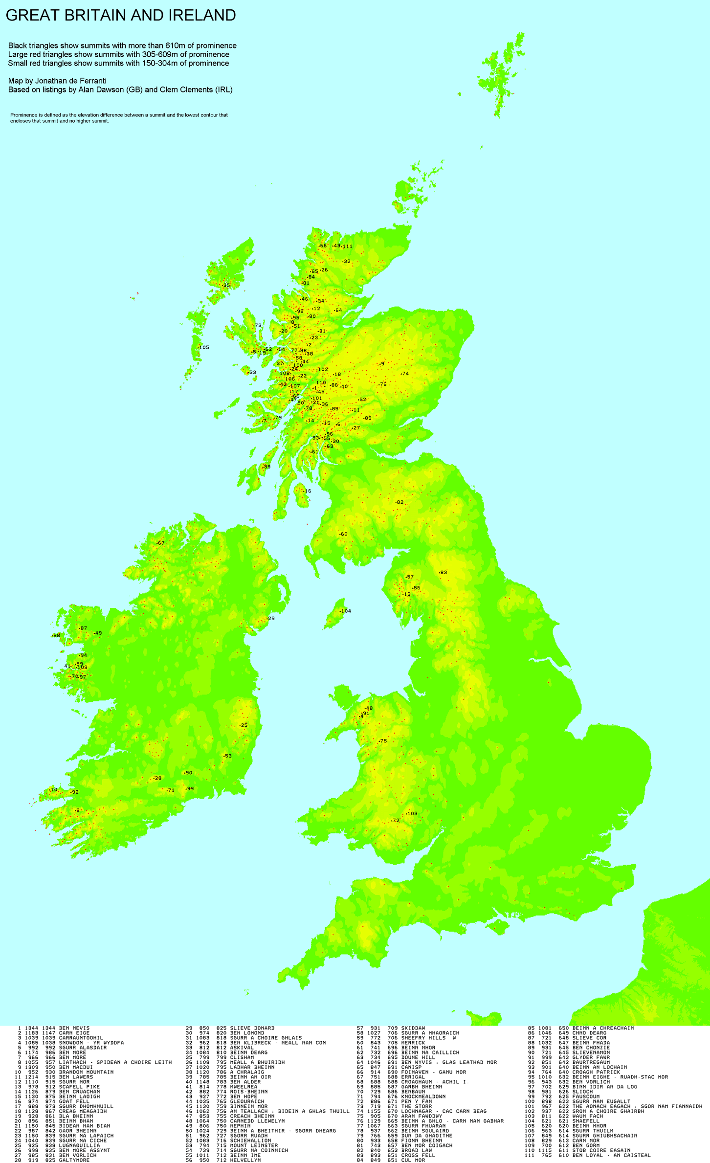
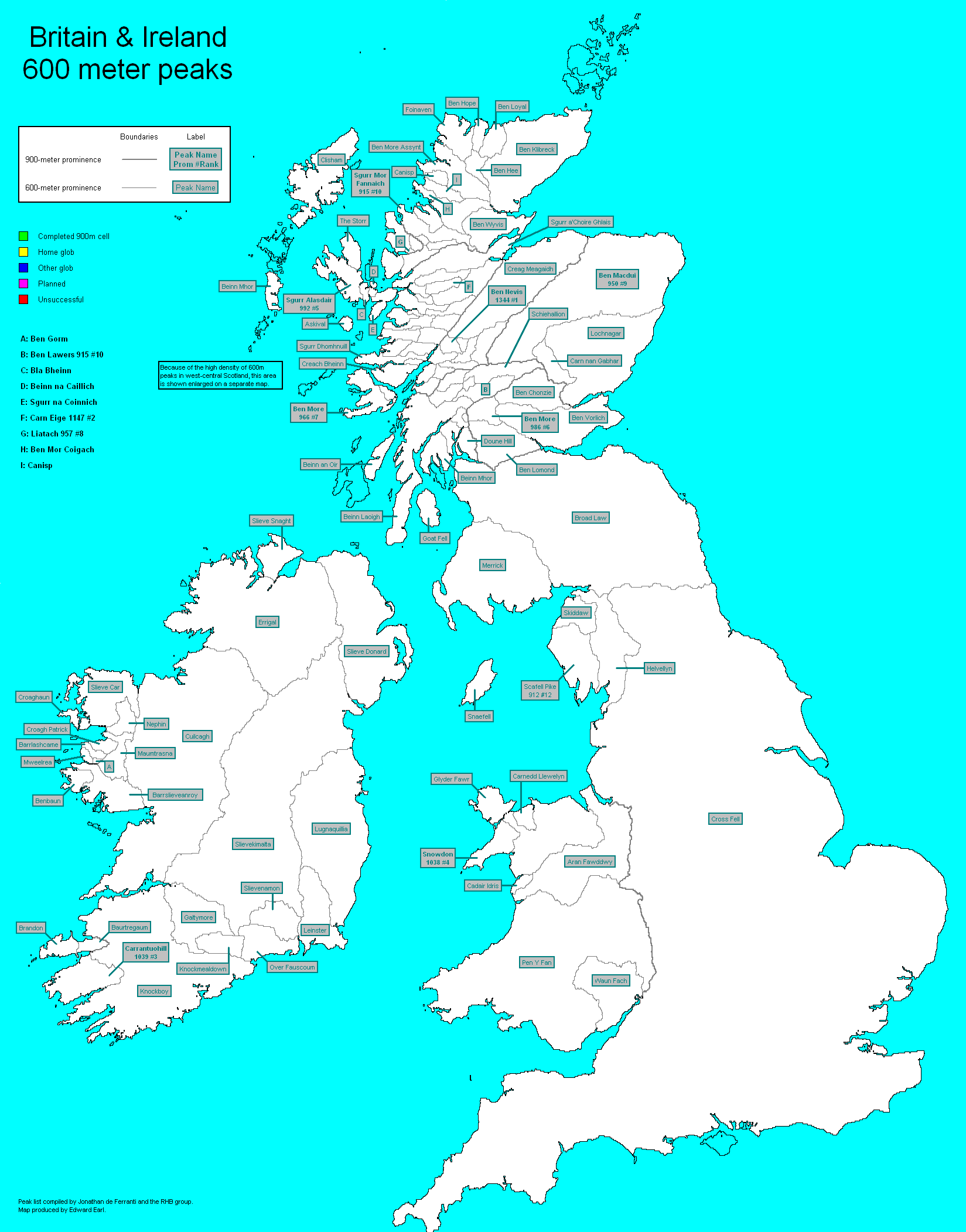
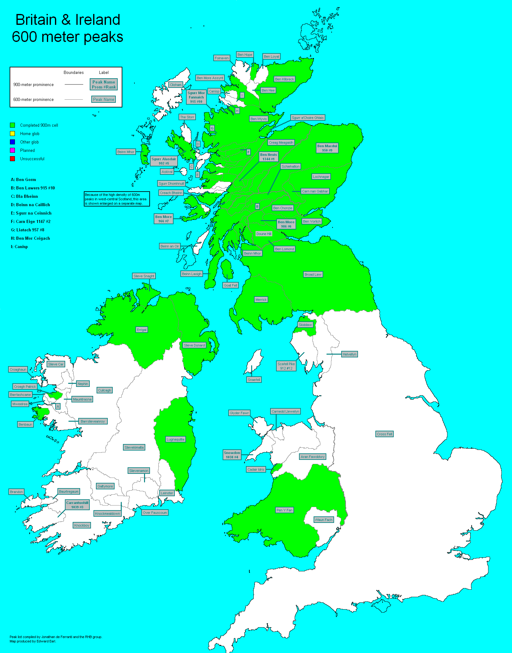
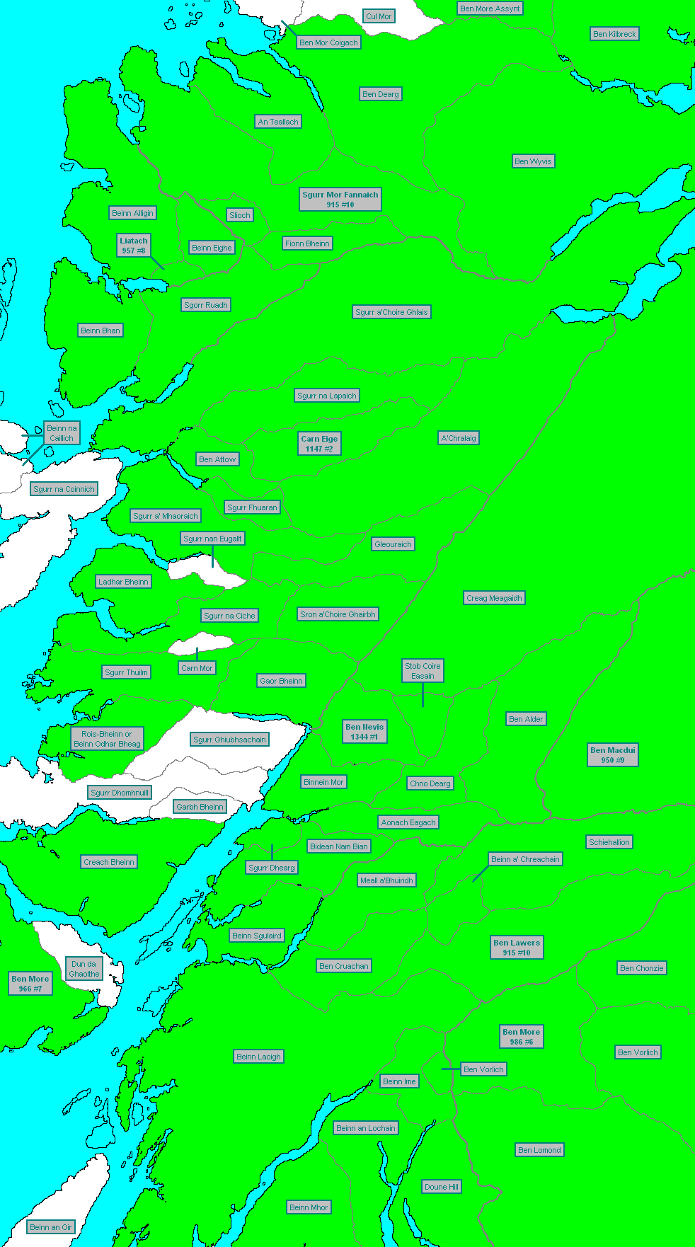
Great Britain and Ireland
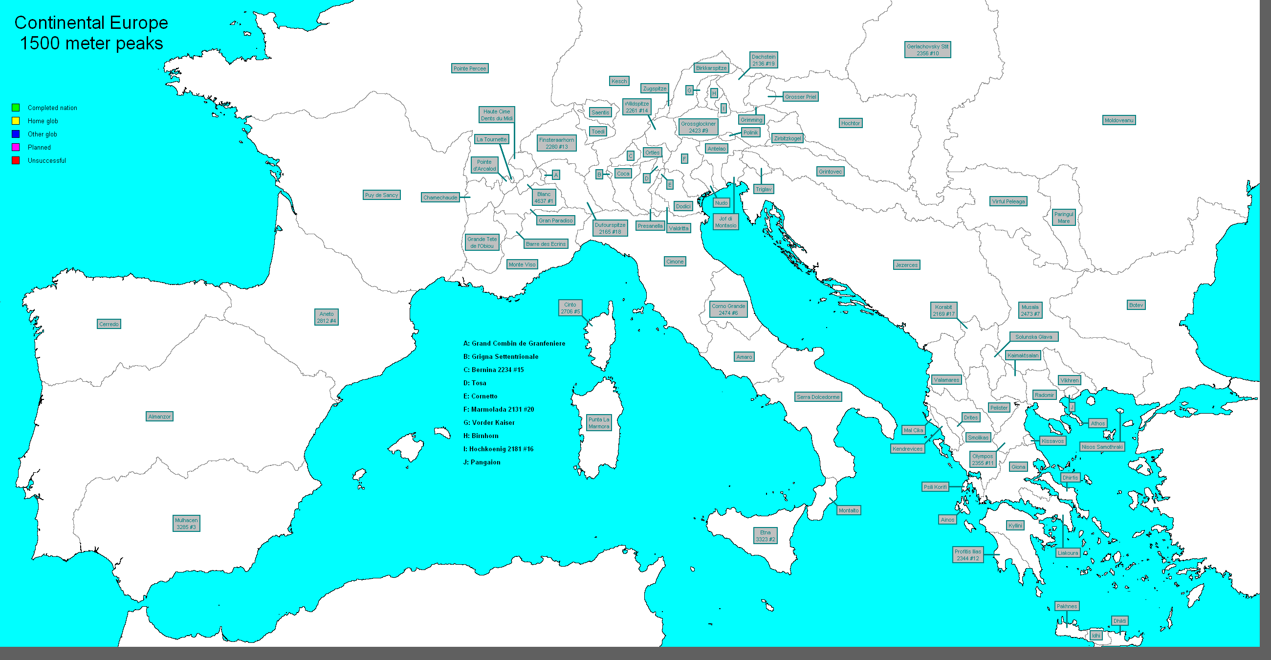
Alps and Western Europe
EUROPE FIRST R100
Europe to R600m
Alps
Text
XLS
CSV
KMZ
Credit: Eberhard Jurgalski
Scandinavia
Text
CSV
KMZ
Includes Norway and Sweden. Credit: Petter Bjorstad
Iberia
Text
CSV
KMZ
Includes both the Spanish and French Pyrenees. Credit: Eberhard Jurgalski, Xavier Eguskitza.
Italy
Text
CSV
KMZ
Includes Corsica and excludes the Italian Alps.
Greece & Balkans
Text
CSV
KMZ
Carpathians
Text
CSV
KMZ
Includes a new R1500m "ultra" in Romania, Pietrosul Rodnei, not yet shown in other lists.
Lower Europe
Text
XLS
CSV
KMZ
To 280m. Includes all areas north and west of the Alps not covered by other sections.
Great Britain and Ireland
Text
CSV
KMZ
To 150m, but may not be 100% up to date with latest research. Credit: Database of British Hills.
Iceland
Text
CSV
KMZ
The KML files display paddles in Google Earth. The color scheme used is as follows: R1500m+ ("ultras"), red; R600m-1499m ("majors"), blue; R150-599m, green.
EUROPE TO R550m" Old file, only map checked to 1450m. See also a completion cell map of Europe to R1500m by Edward Earl, see below.
Large file. Unsorted computer draft. Not map checked; many summits are unnamed.
GREAT BRITAIN TO R30m. Author Mark Jackson. NEW February 2010 Now available in CSV and KML format, with grid references hyperlinked to OSGB mapping, for use in Google Earth. More information.
*GREAT BRITAIN AND IRELAND TO R600m map also marks summits to R150m. Authors Alan Dawson, Clem Clements and Rob Woodall. See also completion cell maps of Britain and Western Scotland by Edward Earl, showing the domains belonging to each summit to R600m. These are defined by tracing the runoffs from the prominence saddles belonging to the summits. They can be be easily colored in by list tickers; my colors can be found here and here.
*Great Britain to R150m. 1554 summits. Author Alan Dawson. Download also a KMZ file for viewing these summits in Google Earth.
Great Britain to R100m A complete list of 2993 British "HuMPs", or hundred metre prominences. Now available as an e-book in PDF format. Last revision September 2010. Compiled by Mark Jackson.
ALPS TO R589m
ALPS TO R450m Older computer draft (June 2004), not map checked
HIGH ALPS to A4000m/R100m, by Mark Trengove. See also Eberhard Jurgalski's high alps list, to 3867m, ranked by orographic dominance.
GERMANY TOP 100 To R367m.
ITALY TO R500m Map checked to just below 589m. Alpine areas are excluded.
ITALY TO R250m Older computer draft, not map checked.
CENTRAL FRANCE TO R250m Computer draft covering area falling between Alps and Pyrenees. Map checked only to R600m.
CORSICA TO R590m Map checked but still in draft format.
JURA AND VOSGES TO R599m Sub-Alpine ranges in Eastern France and NW Switzerland. Authors include Mark Trengove.
JURA TO R150m French Jura Swiss Jura. Authors include Mark Trengove.
*FRANCE TO R150m Author Mark Trengove. Partial coverage; work in progress.
LUXEMBOURG Author Mark Trengove. Some high points, including the ten most prominent.
MONTS DU MORVAN, FRANCE, TO R80m Author Mark Trengove.
RUTOR AND SASSI�RE, French Alps, TO R150m
GRAN PARADISO AREA TO R100m Area of North West Italy. By Mark Trengove.
NETHERLANDS TO R100m Author Mark Trengove.
AUSTRIAN SALZKAMMERGUT and WIENERWALD TO R150m. Author Mark Trengove.
Lower Central Europe
LOWER CENTRAL EUROPE TO R281m The boundaries of Lower Central Europe are definde by tracing the runoffs from the saddle points belonging to the Iberian landmass, the Jura, the Black Forest and the Carpathians. It follows that the Massif Central, Jura, Vosges, Black Forest and Bohemian uplands are included, but the Alps, Pyrenees and Carpathians are not.
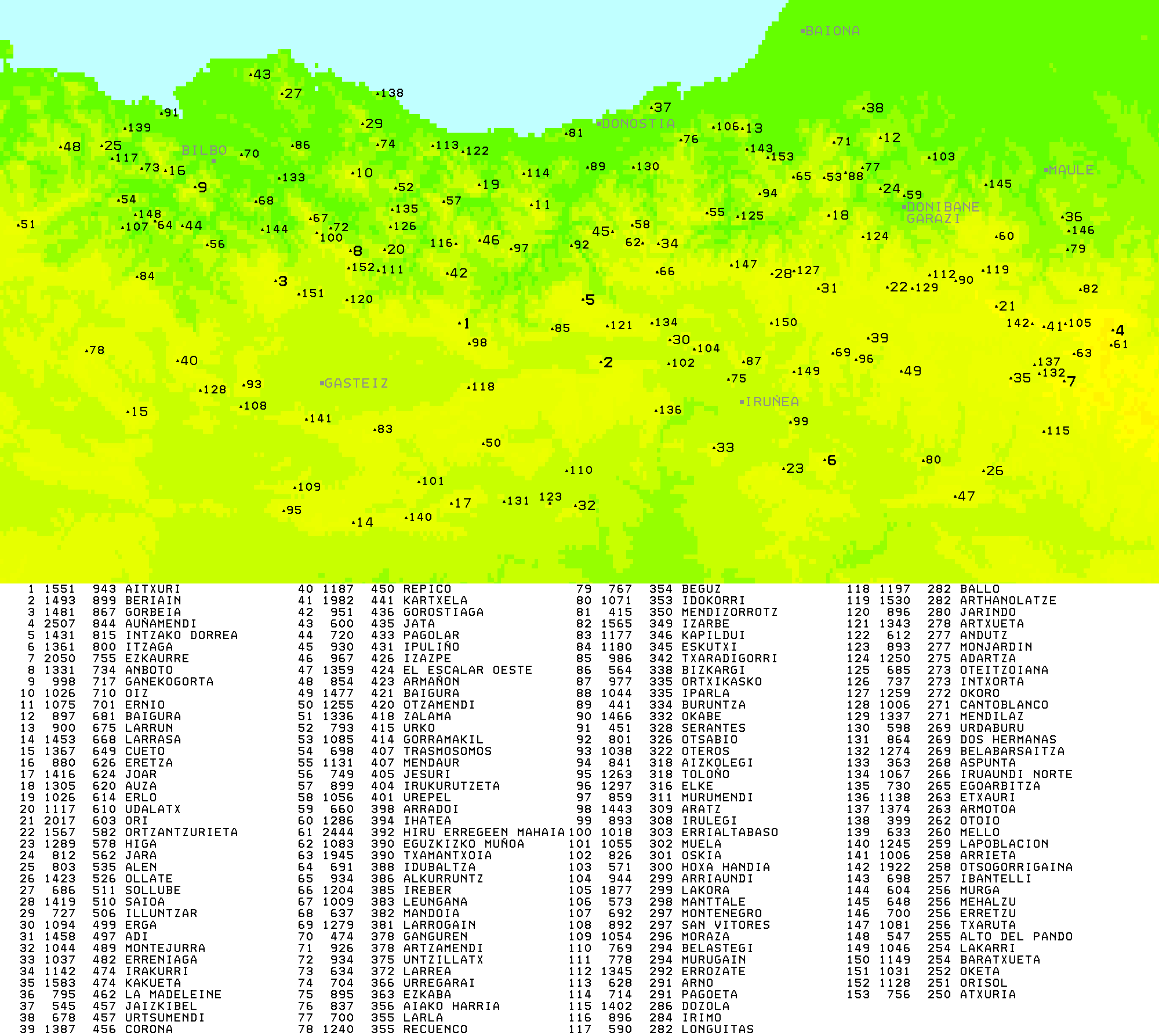
Iberian Peninsula including all the Pyrenees
NEW Mallorca By Eberhard Jurgalski and Xavier Eguskitza.
*BASQUE COUNTRY TO R250m Author Xavier Eguskitza. See also map.
ANDORRA TO R140m. See also preface. By Clem Clements and Mark Trengove.
SPAIN To A3000m/R150m Author Mark Trengove.
Scandinavia
*NORWAY TO R590m Author Petter Bj�rstad.
DENMARK TO R100m Author Mark Trengove.
Eastern Europe
*TATRAS TO R100m Authors Piotr Mielus and Mark Trengove. Popular range on Poland/Slovakia border.
ALL OF POLAND TO R100m Author Piotr Mielus. Most recent revision September 2007.
SLOVAKIA TO R200m Author Piotr Mielus.
POLISH CARPATHIANS TO R100m Author Piotr Mielus. See also a description.
POLISH SUDETY TO R100m Author Piotr Mielus. See also a description.
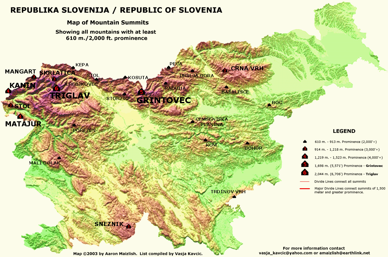
*SLOVENIA TO R300m Author Vasja Kavcic. See also Map to R610m
North America
WESTERN CANADA TO R600m. This is a computer draft, not map checked, and only a few names are provided, but a reasonable guide to the quantity of 2K's is provided. The Alaskan panhandle is included but there is nothing north of 60� or west of 141�.
Australia
AUSTRALIA TO R450m Map checked to 590m.
TASMANIA TO R450m Map checked to 590m.
New Zealand
NORTH ISLAND to R550m
SOUTH ISLAND to R570m
1� x 1� tiles Some lists of summits ranked by prominence, covering 1� x 1� areas, regardless of national frontiers or physical ranges, can be downloaded from here. These tiles are wholly computer generated and have not been map checked. They should not therefore be relied on, but may be useful for prominence research or to anyone looking for possible locally prominent summits.
The process of map checking, sorting and uploading the Asia and South America lists to www.peaklist.org and other sites is in progress, and it is hoped that this process will be extended to the other lists.
A short document by Eberhard about some of the fields in the .xls files can be downloaded here. More explanation will follow in the next few months, but meanwhile here is a table of ranking lists by prominence of US48 summits for various altitude classes.
For further re-ascent rankings (on other sites), go to:
For a discussion of summits whose elevations are, in my opinion, wrong on many Internet sites, click here.
www.peaklist.org (maintained in California by Aaron Maizlish)
www.ii.uib.no/~petter/mountains/mountain-lists.html (maintained in Norway by Petter Bj�rstad)
Why List by Relative Height?
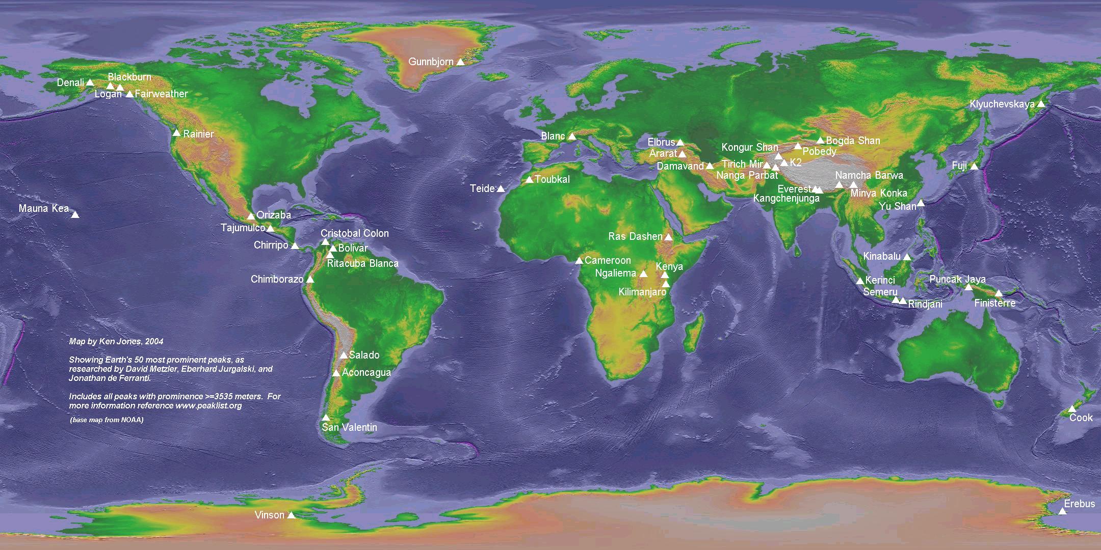
If the world's top 50 summits are ranked by elevation above sea level, then, by any reasonble definition of summit, they are, without exception, on the High Asian plateau. No other area is represented. And many "high" mountains are not true mountains in that they are subsidiary tops belonging to higher mountains, or belonging to ranges containing higher mountains. By contrast, alternative lists, based on elevation high points belonging to nations or other political entities, under-represent High Asia, and represent summits which may be nothing more than high points in cultivated fields. These can be compared with a map of the World's top 50 summits ranked by the definition above. Which best represents the world's greatest mountains?
Under "Highest Mountains", the Penguin Pocket Fact book lists 30. All except Aconcagua and Ojos del Salado are in High Asia. Kangchenjunga S and W peaks, and Broad Middle Peak, are listed, but Denali and Kilimanjaro are not.
Other relative measures. In my opinion, no generally better measure of relative height than re-ascent has been devised. This is discussed in a later section. But for some people, re-ascent does not adequately reward summits which are closely connected to higher summits but which rise very highly and steeply above their surroundings as seen from most directions, e.g. Eiger and Matterhorn. For more information about spire measure click here.
Re-Ascent: Why it is the best general measure.
The need for alternatives to height above sea level is discussed above. But general acceptance of re-ascent has been slowed by some criticisms to which I shall respond.
The first criticism is that the key saddle points, relative to which re-ascent is measured, are often a long way from their corresponding summits. In this way the concept can be labelled abstract. For example, they ask why North American HP Denali is measured relative to a saddle in Nicaragua, several thousand miles away. The reason is this: Denali is the high point of the North American continent, and the lowest point along the watershed divide connecting the North and South American continents is in Nicaragua. (The Panama Canal, being artificial, is excluded). Similarly, if a summit is the high point of a range, its importance is elevated by the importance of that range, and that is affected by its height relative to the lowest point between that range and ranges with higher summits. That seems reasonable to me.
The second criticism is that it gives insufficient rank to some flagship summits, such as Eiger, Matterhorn and Tibet's Holy Mount Kailash, but over-ranks summits like this, the Arabian high point. But re-ascent homes in on range high points, which the former are not, and the Arabian high point is worthy of listing on the grounds that it is the high point of a vast peninsula. Eiger is subsidiary to higher Bernese summits like Finsteraarhorn and Jungfrau. It would even fail the 400m re-ascent rule used by John Biggar in the Andes. Matterhorn may be better known than its higher neighbours Monte Rosa, Weisshorn and Dom, but it is not sufficiently separated from these to attain high ranking by re-ascent. To appreciate its relative elevation properly, click here (and scroll across if necessary). Note that the little known Dent Blanche is only slightly lower and less impressive than Matterhorn. Kailash (aka Kangrinboqe) is a very prominent summit indeed in the general sense; its parent is several hundred kilometres to the east. But is not in the top re-ascent league because there are no low passes through the range, the Trans-Himalayas, to which in belongs. This is an anomaly; some allowance for distance may improve the re-ascent metric, but would compromise its precision. To those searching for impressive mountains, see spire measure, above.
A major advantage of re-ascent is that, wherever you look, it creates very much better tick lists than height. In my country, Scotland, a list of summits over 3000 feet in height has become so well established that it has been compared to an epidemic. But most of Scotland's islands, all of its southern uplands and some rugged parts of its northern and western highlands are excluded from this list because they fall short of 3000 feet. Surely the list of 119 British/Irish summits with 600m of re-ascent (please can we have a name for these?) would be a better goal. Another popular height list is the Alps to 4000m, but there is only one south of the Mont Blanc group and what about the Dolomites and Austrian Alps? This will surely have to give way to the 50 Alps summits with 1500m+ of re-ascent, except for the minority who consider themselves above anything under 4000 metres.
It has been said that height lists give better high level ridge walks linking the summits. But most re-ascent summits are on high level circuits with which they can be combined.
Further advantages of the more widely spread out re-ascent lists are economic and environmental. Summits on height lists tend to be concentrated in small clusters, often served by common centers (e.g. Chamonix, Zermatt). Consequently the local economies of these centers have become overheated and the environmental strain on their surroundings has become a problem. Elsewhere communities are in decline for want of any tourist industry and are dependant on government subsidies for survival. Hillary has complained about too many climbers on Everest. The other 8000ers are under similar pressure. But all over the world there are little known summits with 1500m of re-ascent. So don't annoy Hillary by following in his footsteps. Go here instead and you could be rewarded with a first ascent!
Another advantage of re-ascent is its precise simplicity, and, as far as I know, no alternative measure of relative elevation has been devised, other than spire measure. In my opinion spire measure sits easily alongside re-ascent, but does not compete with it. It misses true summits, and its definition is complex with many subjective parameters, but if you like testing your head for heights, go for it! Attempts have been made to combine re-ascent with elevation and distance dominance, but I am not aware of any general agreement on an appropriate formula.